


Fort Brown Maps
Creation Date
1950
Description
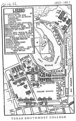
Black and white sketch. Original map located inside the 1950-1951 Texas Southmost College course catalog. Includes building numbers and their corresponding new usage. Unused buildings are not referenced.
Physical Description
.JPG, 1 Map, BW
Preview
Recommended Citation
Fort Brown Maps, UTRGV Digital Library, The University of Texas – Rio Grande Valley. Accessed via https://scholarworks.utrgv.edu/fbmaps/
Keywords
1950-1959, Texas--Fort Brown, Mexico--Matamoros (Tamaulipas), Texas--Brownsville, Texas Southmost College, Military bases -- Texas -- Brownsville, Fortification -- Texas -- Brownsville -- History