


Fort Brown Maps
Creation Date
11-1909
Description
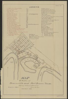
Map of a portion of Brownsville and Fort Brown Texas. Includes location and names of businesses, barracks, and buildings.
Physical Description
.JPG, 1 Map, BW, 74 x 50 cm
Preview
Recommended Citation
Fort Brown Maps, UTRGV Digital Library, The University of Texas – Rio Grande Valley. Accessed via https://scholarworks.utrgv.edu/fbmaps/
Keywords
Riots -- Texas -- Brownsville, Texas--Fort Brown, 1900-1909
