


Fort Brown Maps
Creation Date
11-1909
Description
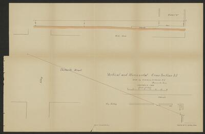
A cross-section map, with a vertical and horizontal section depicting the trajectory of two bullets. It shows portions of Brownsville, Texas related to the investigation of the Brownsville Affray.
Physical Description
.JPG, 1 Map, BW, 38 x 59 cm
Preview
Recommended Citation
Fort Brown Maps, UTRGV Digital Library, The University of Texas – Rio Grande Valley. Accessed via https://scholarworks.utrgv.edu/fbmaps/
Keywords
Riots -- Texas -- Brownsville, Texas--Fort Brown, 1900-1909
