


Fort Brown Maps
Creation Date
3-1869
Description
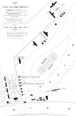
Black and white sketch. "Map of the Post of Fort Brown. Brownsville, Texas. Surveyed and drawn under the direction of Bvt. Maj. Genl. E.R.S. Canby commanding for the military district. L.M. Haupt 2nd Lieutenant Corps. of Engineers U.S.A. March 1869. With approximate changes and additions obtained October 1869 under the direction of Bvt. Maj. Genl. J.J. Reynolds Commanding Genl. Fifth Military District by Captain L.C. Overman Corps of Engineers U.S.A. Made by A. Luor. Note. THe top of the bank is represented by the broken lines. The river bed as surveyed by Sprangenburg 1857 is approximated by the red line. The mark represented by the high water of 1869 is approximated by the yellow line. P.P. is a line of Piles proposed jetties. "
Physical Description
.JPG, 1 Map, BW
Preview
Recommended Citation
Fort Brown Maps, UTRGV Digital Library, The University of Texas – Rio Grande Valley. Accessed via https://scholarworks.utrgv.edu/fbmaps/
Keywords
1860-1869, Texas--Fort Brown, Mexico--Matamoros (Tamaulipas), Texas--Brownsville, Military bases -- Texas -- Brownsville, Fortification -- Texas -- Brownsville -- History