


Lower Rio Grande Valley Maps
Identifier
Banco map 89529
Creation Date
11-16-1912
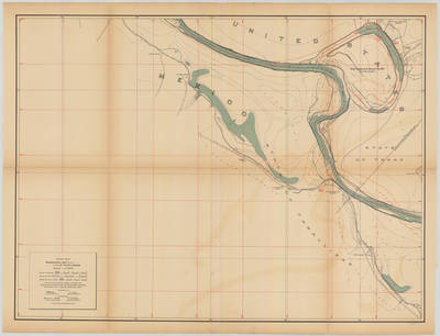
Description
[Banco map 89529] Ranches include: Santo Domingo Ranch, San Francisco Ranch, Negro Ranch, Garcia Ranch, Los Fresnos Ranch, Tepeguage Ranch, Lobera Ranch, Cipres Ranch, and Lopez Ranch.
Physical Description
.JPG, 1 Map ; Scale 1 in 10,000
Preview
Recommended Citation
Topographical Map of the Rio Grande From Roma To The Gulf Of Mexico Sheet No. 05, Banco map 89529. (1912). Proceedings of the International Boundary Commission, United States and Mexico, American Section. UTRGV Digital Library, The University of Texas – Rio Grande Valley. Accessed via https://scholarworks.utrgv.edu/maps
Keywords
Bancos, Boundaries, International Boundary Commission, Maps, Texas--Lower Rio Grande Valley, 1910-1919
