


Lower Rio Grande Valley Maps
Identifier
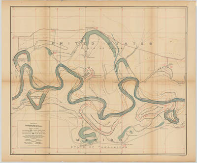
Banco map 89541
Creation Date
11-16-1912
Description
[Banco map 89541] Ranches include: Nogales Ranch, Sandel Ranch, Agua Negra Ranch, Pajaritos Ranch, San Pedro Ranch, Rancho Nuevo, Arguelles Ranch, San Jose Ranch, Puertas Ranch, Santa Juanita Ranch, San Ysidro Ranch, Manuel Ranch, Sabinito Ranch, Vera Cruz Ranch, San Lorenzo Ranch, El Ranchito, Ladrillera Ranch, Toluca Ranch.
Physical Description
.JPG, 1 Map ; Scale 1 in 10,000
Preview
Recommended Citation
Topographical Map of the Rio Grande From Roma To The Gulf Of Mexico Sheet No. 17, Banco map 89541. (1912). Proceedings of the International Boundary Commission, United States and Mexico, American Section. UTRGV Digital Library, The University of Texas – Rio Grande Valley. Accessed via https://scholarworks.utrgv.edu/maps
Keywords
Bancos, Boundaries, International Boundary Commission, Maps, Texas--Lower Rio Grande Valley, 1910-1919
