


Lower Rio Grande Valley Maps
Identifier
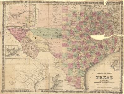
NewMapOfTheStateOfTexasAsItIsIn1874, 1874
Creation Date
1874
Description
New Map of the State of Texas as it is in 1874. Plan of the Northern Part or Panhandle of Texas, Plan of Matagorda Bay, Texas as it was in 1835 under Mexican Rule, Plan of Galveston Bay and Plan of Sabine Park Prepared Expressly for Morphis' History of Texas. Published by the U.S. Publishing Co., New York.
Physical Description
.JPG, 1 Page, Color
Preview
Recommended Citation
Colton, G. Woolworth. (1874). New Map of the State of Texas : As It Is In 1874. Maps, UTRGV Digital Library, The University of Texas – Rio Grande Valley. Accessed via https://scholarworks.utrgv.edu/maps
Keywords
Maps, Texas, 1870-1879
