


Lower Rio Grande Valley Maps
Creation Date
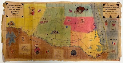
1956
Description
Hand-drawn and hand-colored map of the Lower Rio Grande Valley of Texas created by the Edinburg chapter of the Junior Historians. Schematics include old trails, towns, county seats, ranches, plantations, "indian tribes" / Native Americans, forts and battles. Also includes insets of early land grants, flgas, and more.
Physical Description
Color, 89 x 47 cm
Preview
Recommended Citation
Edinburg Junior Historians Chapter 9S; Fesler, Ken Wayne; and Dugan, Frank H., "Histro-Map of the Lower Rio Grande Valley" (1956). Lower Rio Grande Valley Maps. 94.
https://scholarworks.utrgv.edu/maps/94
Keywords
map, hand-drawn, Hidalgo County, Willacy County, Starr County, Cameron County, Kenedy County, Mexico, Texas, history, geography, trails
