



John H. Shary Collection
Identifier
Map of Pecan Heights (red pencil).jpg
Files
Download Item (1.9 MB)
Creation Date
1954
Keywords
Texas--Sharyland, Texas--Mission, Texas--Hidalgo County, Pecan Heights, West Addition to Sharyland, subdivision plat, John H. Shary Inc., State Highway US 83, Missouri Pacific Railroad, East Twelfth Street, East Eleventh Street, East Tenth Street, Highland Park, Bryan Road, survey map, red pencil annotations, lot measurements
Description
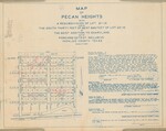
Subdivision map of Pecan Heights, a resubdivision of Lot 21-10 and the south thirty feet of the west 660 feet of Lot 22-10 in the West Addition to Sharyland, Hidalgo County, Texas. The plat depicts numbered blocks and residential lots, East Twelfth, East Eleventh, and East Tenth Streets, Highland Park, Bryan Road, State Highway U.S. 83, a park, and the Missouri Pacific Railroad. Red and graphite pencil annotations mark several lots and include measurements, calculations, crossed lines, and notes along the subdivision and surrounding margins. The printed certification and dedication text identifies John H. Shary Inc. and describes the dedication of streets and alleys and provisions for utilities, canals, and drainage ditches.
Physical Description
.JPG, 1 Map, Linen Blueprint
Recommended Citation
Shary, John H., "Map of Pecan Heights, West Addition to Sharyland with Red Pencil Lot Annotations" (1954). John H. Shary Collection. 147.
https://scholarworks.utrgv.edu/johnshary/147
