



Lower Rio Grande Valley Maps
Creation Date
1966
Description
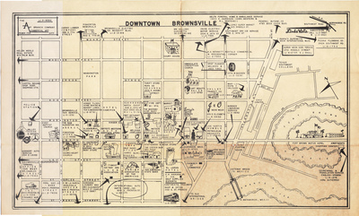
A mid-20th-century promotional business directory map illustrating the layout of downtown Brownsville, Texas, and its connection across the Rio Grande to Matamoros, Mexico. The layout uses a grid format to plot major downtown avenues, marking commercial structures, civil landmarks, and specific storefront footprints. Graphic cartoon illustrations decorate the lower margins, depicting regional motifs and local cross-border transport options.
Physical Description
.JPG, 1 Page, BW
Preview
Recommended Citation
"Map of Downtown Brownsville, Texas" (1966). Lower Rio Grande Valley Maps. 101.
https://scholarworks.utrgv.edu/maps/101
Keywords
Maps, City directories, Commercial maps, Texas--Brownsville, Texas--Lower Rio Grande Valley, Commerce, Central business districts, International bridges, 1960-1969
