



Lower Rio Grande Valley Maps
Identifier
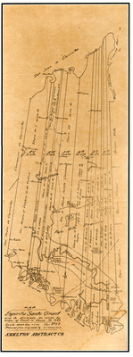
EspirituSantoGrant
Creation Date
1889
Description
A historical land map detailing the long, narrow vertical tract subdivisions of the Spanish colonial land grant known as the Espíritu Santo Grant in South Texas. The map illustrates the boundary lines and allocations for individual family property partition shares, tracing land ownership records in the area.
Physical Description
.JPG, 1 Page, BW
Preview
Recommended Citation
Cocke, J. J., "Map of Espritu Santos Grant and Its Divisions as Made by Order of Court in Cause No. 1346." (1889). Lower Rio Grande Valley Maps. 107.
https://scholarworks.utrgv.edu/maps/107
Keywords
Maps, Texas--Brownsville, Texas--Palo Alto Prairie, Texas--Lower Rio Grande Valley, Land Grants, Property
