



Lower Rio Grande Valley Maps
Identifier
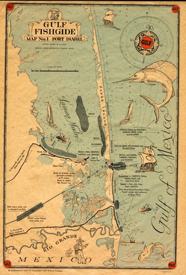
BD0041 Anthony Reisinger Gulf Fish Guide Map No 1 Port Isabel
Creation Date
1939
Description
A vintage commercial pictorial promotional roadmap and fishing chart published by the Gulf Oil Corporation to detail the coastal waters of South Texas and northern Mexico. The map illustrates prime coastal fishing spots across the Laguna Madre, Padre Island, and the mouth of the Rio Grande. It is densely decorated with mid-20th-century cartoon illustrations of regional fishermen, local wildlife, and various sport fish, framed at the margins by classic round Gulf gasoline logos.
Physical Description
.JPG, 1 Page, Color
Preview
Recommended Citation
Gulf Oil Corporation, "Map of Gulf Fishguide, No.1 Port Isabel" (1939). Lower Rio Grande Valley Maps. 102.
https://scholarworks.utrgv.edu/maps/102
Keywords
Maps, Texas--Port Isabel, Texas--Padre Island, Texas--Laguna Madre, Fishing, Rio Grande, Gulf Oil Corporation, 1939
