



Lower Rio Grande Valley Maps
Identifier
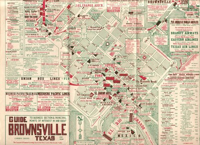
Guide to Brownsville, TX by Russell M White
Creation Date
1950
Description
A 1950s vintage promotional pictorial street grid and merchant directory map illustrating the business section of downtown Brownsville, Texas. The map features color-coded arterial grids detailing local school zones, public plazas, and neighborhood sectors alongside commercial storefront footprints labeled with their 1950s historic telephone exchange numbers. The map also includes dense statistical directories and text boxes highlighting regional transport options, listing municipal church congregations, tracking Union Bus Line departures, routing Missouri Pacific transit connections, and indexing a comprehensive local classified business directory to guide winter tourists and commercial shoppers.
Physical Description
.JPG, 1 Page, Color
Preview
Recommended Citation
White, Rusell M., "Map of Guide to Brownsville, Texas" (1950). Lower Rio Grande Valley Maps. 113.
https://scholarworks.utrgv.edu/maps/113
Keywords
Maps, Texas--Brownsville, Texas--Lower Rio Grande Valley, Mexico--Matamoros, Commercial Maps, City Directories, Central Business Districts, Bus Lines, International Bridges, 1950-1959
