



Lower Rio Grande Valley Maps
Identifier
BD0018-ca1846-MapofUS&Texas-030
Creation Date
1839
Description
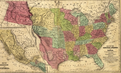
A hand-colored historical school map containing two primary geographic layouts, documenting the political and territorial boundaries of North and Central America in 1839. The main upper map details the geopolitical layout of the United States alongside the Republic of Texas extending northward to the Arkansas River. The lower left inset map provides a regional view of the Republic of Mexico, the Yucatan peninsula, and Guatemala prior to the border changes of the Mexican-American War.
Physical Description
.JPG, 1 Page, Color
Preview
Recommended Citation
Stiles, Samuel; Sherman, George Edwin; Smith, John Calvin; and Stiles, Sherman, & Smith, "Map of the United States and Texas [and] Map of Mexico and Guatimala" (1839). Lower Rio Grande Valley Maps. 103.
https://scholarworks.utrgv.edu/maps/103
Keywords
Maps, United States, Republic of Texas, Oregon Territory, Missouri Territory, Indian Territory, Mexico, Gulf of Mexico, Guatemala, Boundaries, 19th Century, 1830-1839
