


Lower Rio Grande Valley Maps
Identifier
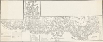
MapShowingLinesMarchBorderPatrolsMexicanBorderService, 1916-1917
Creation Date
1917
Description
Map depicting the lines of march and patrolling of the border during the Mexican Border War (1910–1919)/Border Campaign. Includes legend that shows where camps, outposts, pumping plants, hospitals, churchers, telephone lines, rifle rangers and forts are located.
Physical Description
.JPG, 1 Page, BW
Preview
Recommended Citation
Rice, C.A. (1917). Map Showing Lines of March and Border Patrols In My Mexican Border Service. Maps, UTRGV Digital Library, The University of Texas – Rio Grande Valley. Accessed via https://scholarworks.utrgv.edu/maps
Keywords
Mexican Border War (1910–1919), Texas--Rio Grande Valley, 1910-1919, United States. Army
