



Lower Rio Grande Valley Maps
Identifier
MEXMATA1
Creation Date
1846
Description
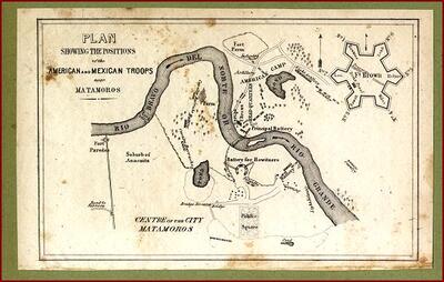
A historical military tactical plan mapping the combat positions, batteries, and encampments of the American and Mexican armies along the Rio Grande loops near Matamoros and Fort Brown in 1846. The map illustrates the central curve of the river, labeled "Rio Bravo del Norte or Rio Grande," separating the urban grid of the "Centre of the City Matamoros" and its public square from the opposing American camp and its artillery lines on the northern bank. A highly detailed engineering inset in the upper right corner charts the star-shaped layout of the fortification bastions for Fort Brown.
Physical Description
.JPG, 1 Page, BW
Preview
Recommended Citation
"Map of Plan Showing the Positions of the American and Mexican Troops" (1846). Lower Rio Grande Valley Maps. 108.
https://scholarworks.utrgv.edu/maps/108
Keywords
Maps, Texas--Brownsville, Texas--Lower Rio Grande Valley, Mexico--Matamoros, Fort Brown, Tactical Maps, United States Army, Mexican Army, Mexican-American War, 1846-1848
