


Lower Rio Grande Valley Maps
Identifier
General Map Collection Texas Historic Overlay Map Research & Digitization Project
Creation Date
1854
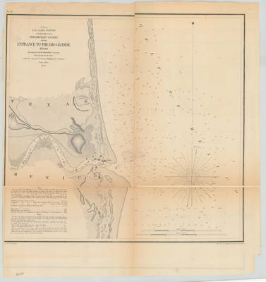
Description
U.S. Coast survey. A.D. Bache, Superintendent. Preliminary survey of the entrance to the Rio Grande, Texas. Topography by W.E. Greenwell, assistant. Hydrography by the party under the command of Lieutenant J. Wilkinson U.S.N. Asst. Scale 20,000. Cities of Bagdad and Clarksville are present. Relief shown by hachures. Includes text on soundings and tides. Prime meridian: Greenwich. Engraved by C.A. Knight & F.W. Benner.
RioGrandeEntrance_1854_USCS_00114-1.TIF
Physical Description
.JPG, 1 Map ; Scale 20,000
Preview
Recommended Citation
Greenwell, W.E. (1854). Preliminary survey of the entrance to the Rio Grande, Texas. Maps, UTRGV Digital Library, The University of Texas – Rio Grande Valley. Accessed via https://scholarworks.utrgv.edu/maps
Keywords
Maps, North America--Rio Grande, Texas--Lower Rio Grande Valley, 1850-1859
