


Lower Rio Grande Valley Maps
Identifier
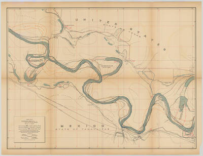
Banco map 89535
Creation Date
11-16-1912
Description
[Banco map 89535] Ranches include: Ojo de Agua Ranch, Hedley Ranch, Texas Ranger, King's Ranch, Barranco Ranch, Los Fresnos Ranch, Parida Ranch, Morillo Ranch, Anzaldua Ranch, Cavazos Ranch, Brooks Ranch, Jardin De Flores Ranch.
Abram Dillard's home and store are shown in the map.
Physical Description
.JPG, 1 Map ; Scale 1 in 10,000
Preview
Recommended Citation
Topographical Map of the Rio Grande From Roma To The Gulf Of Mexico Sheet No. 11. (1912). Proceedings of the International Boundary Commission, United States and Mexico, American Section. UTRGV Digital Library, The University of Texas – Rio Grande Valley. Accessed via https://scholarworks.utrgv.edu/maps
Keywords
Bancos, Boundaries, International Boundary Commission, Maps, Texas--Lower Rio Grande Valley, 1910-1919, Texas--Perezville, Texas--Bentsen-Rio Grande Valley State Park
