


Lower Rio Grande Valley Maps
Identifier
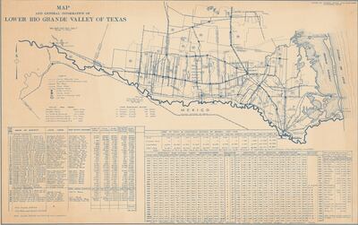
MapAndGeneralInformationOfLowerRioGrandeValleyOfTexas,ND
Creation Date
1938
Description
Includes: data for water districts, fruit and vegetable shipping from 1926 to 1937, temperature and precipitation data for 1911-1937, statistics on all valley rail road lines, and town and county information including elevations and census information for 1920, and 1930.
Physical Description
.JPG, 1 Page, BW, Scale in miles
Preview
Recommended Citation
Tamm, Alfred. (1938). Map and general information of Lower Rio Grande Valley of Texas. Maps, UTRGV Digital Library, The University of Texas – Rio Grande Valley. Accessed via https://scholarworks.utrgv.edu/maps
Keywords
Maps, Texas--Lower Rio Grande Valley, 1930-1939, Statistics
