



Lower Rio Grande Valley Maps
Identifier
MAPA Valle de Texas1937
Creation Date
1937
Description
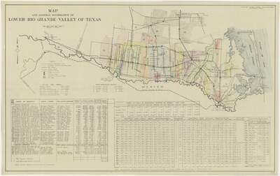
A highly detailed regional civil engineering and infrastructure map documenting the irrigation networks, property districts, and agricultural statistical profiles of the Lower Rio Grande Valley of Texas in 1937. The upper portion displays a comprehensive territorial layout plotting numbered water and drainage districts, railway line segments, improved dirt or surfaced highways, and major towns spanning the international border line along the Rio Grande. The lower half of the document contains dense statistical grids that index local water improvement districts by name, track seasonal carloads of exported fruits and vegetables from 1907 to 1926. There are logged decades of monthly and annual precipitation measurements, and outline local population metrics.
Physical Description
.JPG, 1 Page, Color
Preview
Recommended Citation
Tamm, Alfred, "Map and General Information of Lower Rio Grande Valley of Texas" (1937). Lower Rio Grande Valley Maps. 110.
https://scholarworks.utrgv.edu/maps/110
Keywords
Maps, Texas--Hidalgo County, Texas--Cameron County, Texas--Lower Rio Grande Valley, Civil Engineering, Irrigation Districts, Water Supply, Statistics, 1930-1939
