


Lower Rio Grande Valley Maps
Identifier
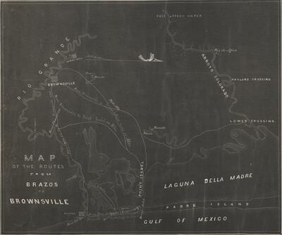
MapoftheRoutesfromBrazostoBrownsville, ND
Creation Date
1850
Description
Black and white. Map showing rivers, the Laguna Madre, crossings, points, towns, ranches, islands, roads and routes, with distances given between points, a proposed road along the beach, and location of fresh water. ca.1845-1850.
Physical Description
.TIFF, 1 Page, BW
Preview
Recommended Citation
Map of the Routes from Brazos to Brownsville. (1850). Maps, UTRGV Digital Library, The University of Texas – Rio Grande Valley. Accessed via https://scholarworks.utrgv.edu/maps
Keywords
Maps, Texas, 1840-1849, 1850-1859, Mexican-American War (1846-1848), Springs, Texas--Brownsville, Texas--Boca Chica
