


Lower Rio Grande Valley Maps
Identifier
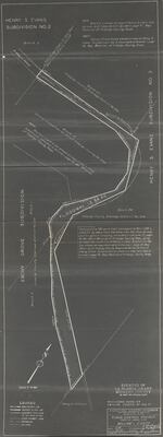
LaBlancaGrantFloodControlProjectHidalgoCounty, 1939-01-11
Creation Date
1-11-1939
Description
Flood control project map depicting floodway channel going through Ebony Grove subdivision, Hidalgo County Drainage District No. 1, and the Henry S. Evans Subdivision No. 2.
Physical Description
.JPG, 1 Page, BW, Scale: 1" = 200'
Preview
Recommended Citation
International Boundary & Water Commission, United States & Mexico. (1939). Flood Control Project Floodway Channel: La Blanca Grant, Hidalgo County. Maps, UTRGV Digital Library, The University of Texas – Rio Grande Valley. Accessed via https://scholarworks.utrgv.edu/maps
Keywords
Maps, Texas--La Blanca, Flood control, Texas--Donna, Irrigation districts, 1930-1939
