


Lower Rio Grande Valley Maps
Identifier
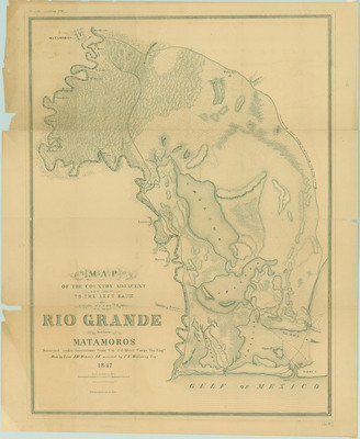
1847MapaDelPaisAlNorteDelRioBravo, 1847
Creation Date
1847
Description
A military reconnaissance map published in 1847, showing the strategic topography adjacent to the left bank of the Rio Grande. The cartography covers the coastal delta region extending inland from the Gulf of Mexico toward Matamoros. Scale [1:63,360].
Physical Description
.JPG, 1 Page, BW
Preview
Recommended Citation
Abert, John James, "Map of the country adjacent to the left bank of the Rio Grande below Matamoros" (1847). Lower Rio Grande Valley Maps. 98.
https://scholarworks.utrgv.edu/maps/98
Keywords
Maps, Texas--Brownsville, Texas--Lower Rio Grande Valley, Mexico--Matamoros, Gulf of Mexico, Boca Chica Beach, United States Army, Mexican Army, 1847, 1846-1848
