


Lower Rio Grande Valley Maps
Identifier
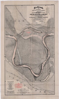
BlancoMapDepictingEmorySalazarChannel1898, 1898-01
Creation Date
1-1898
Description
An official international boundary survey map documenting a highly detailed oxbow bend of the Rio Grande along the border between Texas and Tamaulipas. Constructed from surveys made in 1898 under the authority of the International Boundary Commission, this specific sheet was finalized in October 1900.
Physical Description
.JPG, 1 Page, Color, Scale = 1:5000
Preview
Recommended Citation
International Boundary & Water Commission, United States & Mexico., "Map of Rio Grande from San Juan River to the Gulf of Mexico showing Boundary between the United States and Mexico - Emory Salazar Channel" (1898). Lower Rio Grande Valley Maps. 99.
https://scholarworks.utrgv.edu/maps/99
Keywords
Maps, Texas--Hidalgo County, Texas--Lower Rio Grande Valley, Mexico--Tamaulipas, International Boundaries, Rio Grande River
