


Mapas del Archivo General de la Nación
Identifier
BD00026-Catalogo de ilustraciones #450
Creation Date
1-1-1806
Description
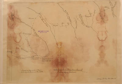
Map of route that Marques de San Miguel de Aguayo made in the year of 1722, in a file on the limits of Texas.
Escala de 60 leguas castellanas. Scale of 60 Spanish leagues.
Physical Description
.JPG, 1 Map, 46.5 x 34 cm
Preview
Recommended Citation
Mapas del Archivo General de la Nación, UTRGV Digital Library, The University of Texas – Rio Grande Valley. Accessed via https://scholarworks.utrgv.edu/archgeneralnacion/
Keywords
Maps, Texas--Brazos River, Texas--Colorado River, Texas--Guadalupe River, Texas--Neches River, Texas--San Antonio River, Texas--Trinity River, United States--Sabine-Neches Estuary, 1800-1809
