



John H. Shary Collection
Identifier
Hidalgo County Drainage District One.jpg
Files
Download Item (3.5 MB)
Creation Date
9-9-1940
Keywords
Texas--Sharyland, Texas--Hidalgo County, flood control, levee right-of-way, Hidalgo County Drainage District No. 1, John H. Shary Subdivision, Southern Land and Water Company Subdivision, United Irrigation Company, levee system, land acquisition, engineering map, survey map, International Boundary and Water Commission
Description
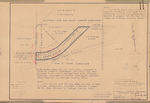
Survey map depicting levee right-of-way acquisition for the Hidalgo County Drainage District No. 1 flood control project within Lots 121, 122, and 123 of the John H. Shary Subdivision. The map shows property boundaries, acreage conveyed for levee construction, adjacent landowners, irrigation infrastructure, and right-of-way measurements associated with the Lower Rio Grande flood control system.
Physical Description
.JPG, 1 Page, BW
Recommended Citation
Shary, John H., "Map of Levee Right-of-Way Acquisition in Lots 121-123 of the John H. Shary Subdivision" (1940). John H. Shary Collection. 137.
https://scholarworks.utrgv.edu/johnshary/137
