



John H. Shary Collection
Identifier
Main Floodway Channel right of way located in Porcion 59 & 60.jpg
Files
Download Item (6.5 MB)
Creation Date
8-3-1940
Keywords
Texas--Sharyland, Texas--Hidalgo County, flood control, main floodway channel, floodway, John H. Shary Subdivision, Porciones 59-60, United Irrigation Company, Bankers Mortgage Company, canal right-of-way, land acquisition, engineering map, survey map, International Boundary and Water Commission
Description
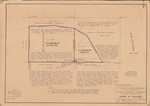
Survey map depicting main floodway channel right-of-way acquisitions across Lots 136, 137, 146, and 147 of the John H. Shary Subdivision in Porciones 59 and 60, Hidalgo County. The map shows floodway acreage, canal rights-of-way, property boundaries, adjacent landowners, and land conveyances required for construction of the Lower Rio Grande flood control system.
Physical Description
.JPG, 1 Page, BW
Recommended Citation
Shary, John H., "Map of Main Floodway Channel Right-of-Way Across Lots 136, 137, 146, and 147 in the John H. Shary Subdivision" (1940). John H. Shary Collection. 142.
https://scholarworks.utrgv.edu/johnshary/142
