



Lower Rio Grande Valley Maps
Identifier
Map-SoPac RR-LRGV
Creation Date
1928
Description
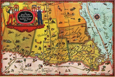
A vibrant 1928 vintage pictorial promotional railroad map illustrating the counties of South Texas along the Rio Grande. The map features brightly colored territorial grids for Starr, Hidalgo, Willacy, Cameron, Brooks, Jim Hogg, and Kenedy counties. This map highlights the routes of the Southern Pacific Lines railroad threading through regional towns. From the promotional book: Montgomery, Julia Cameron. A Little Journey Through the Lower Valley of the Rio Grande: The Magic Valley of Texas. Rein, 1928.
Physical Description
.JPG, 1 Page, Color
Preview
Recommended Citation
Montgomery, Julia Cameron and Stedman, Wilfred, "Map of The Lower Valley of the Rio Grande Served by the Southern Pacific Lines" (1928). Lower Rio Grande Valley Maps. 111.
https://scholarworks.utrgv.edu/maps/111
Keywords
Maps, Texas--Lower Rio Grande Valley, Texas--Cameron County, Texas--Hidalgo County, Railroads, Southern Pacific Lines, Agricultural Industries, 1920-1929
