


Lower Rio Grande Valley Maps
Identifier
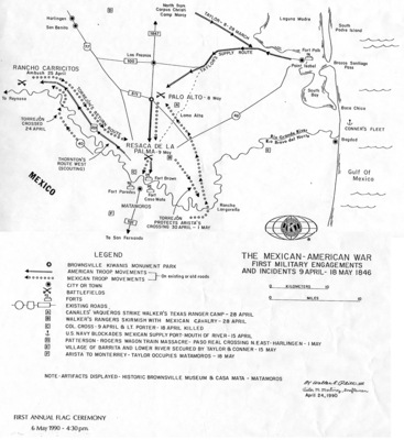
1846Mex-Amer-War, 1990-04-24
Creation Date
4-24-1990
Description
A modern historical reference map illustrating the theater of military operations, troop movements, and initial clashes of the Mexican-American War along the Rio Grande delta between April 9 and May 18, 1846. The map illustrates the geography connecting South Texas and Northern Mexico.
Physical Description
.JPG, 1 Page, BW
Preview
Recommended Citation
Plitt, Walter E. III and Martinez, Victor M., "Map of The Mexican-American War, first military engagements and incidents 9 April - 18 May 1846" (1990). Lower Rio Grande Valley Maps. 97.
https://scholarworks.utrgv.edu/maps/97
Keywords
Maps, Texas--Brownsville, Texas--Lower Rio Grande Valley, Military Campaigns, Tactical Maps, Troop Movements, Skirmishes, United States Army, Mexican Army, 1846, 1846-1848
